The UEFA European Championships start this Friday, aka “the Euros”. In years gone by I have drawn MS Paint images of the new kits and discussed those ahead of the tournament. I’m not saying I haven’t done that this year (I definitely have, just a few weeks ago, but then a few of the kits suddenly got changed and now I don’t want to. Besides, I am sick of football. I am. This has been a grind of a season, there has been too much of it, and now we have a tournament in an odd-numbered year, set in how many countries? During a pandemic that is simultaneously getting better and worse. Of course, I’ll love it when it starts. I might even cheer for England (though I got the Scotland shirt this time round). I made my wallchart (complete with pictures of players whoa re now going to miss it through injury), ordered a banner, and will put the usual paper mosaic flags on the wall, taking them down every time a country is eliminated. Who will win? England? Maybe Belgium? Probably France. I’m sick of football, but I love it too much. So I started drawing some classic footballers in Adobe Illustrator, one image from each of the tournaments, and so I thought I’d write a post about the Euros that have meant the most to me, that is, the ones between the ages of 12 and 28, after which I moved to America. It’s a story of my life, intertwined with the Euros, and paints as much a picture of me as it does the players I’ve drawn, so here goes. This will be a long, long post. It might be worth grabbing a cup of tea. We will kick off in 1988…

EURO 88 – Orange Boom. The first European Championships that I can remember. I did know that France had apparently won something in 1984, because in World Cup 86 they talked about the 84 France team of Platini and Tigana, about how good the Belgians were, but it wasn’t on TV in England and literally nobody cared about it so it may as well have been a tennis tournament. When the Euros of 1988 came around, held in West Germany, we heard more about it, but still it was the European Championships, with only eight teams, hardly the World Cup. A bit like watching the European athletics championships when you’re only interested in the Olympics, but even less glamourous. Eight teams; this number didn’t change until 1996, but in 1988 there were far fewer countries in Europe than today, despite there being two Germanies. England were in it this time though, and so were Jack Charlton’s Republic of Ireland, and in 1988 that was a pretty big deal to our family, and it’s where my love of the Irish national team started. Around that time we were very much into our Irishness, going to the Irish Festival week in Southport twice a year, the sound of Brendan Shine and Philomena Begley playing out of our windows, and when Ireland actually beat England 1-0 in the Euros…well, that was celebrated quite wildly. I still have the shirt my mum brought me back from the London Irish Festival in Roundwood Park, Kilburn, a week later that says “These Boys Made History” with a photo of the team (a photo on a t-shirt! That technology was like sorcery to me in 1988) and the result on the other side. We were very much in Jackie’s Army ever since, and when Ireland play at a tournament with England, I’m always supporting them first, England second. Apart from that, there wasn’t a lot I paid attention to at Euro 88, which I still thought of as a fringe tournament (fringes and mullets, at least where Hoddle and Waddle were concerned). Until the final. We watched the final, the USSR with their CCCP emblazoned white shirts, and Holland, the greatest team who had never won anything (them and Hungary, as history books would tell me). The Dutch had those unusual orange shirts with the many gradients mixed up with chevrons, and Adidas classic now but not loved by the players at the time. They also had the three great Flying Dutchmen of Gullit, Rijkaard…and Marco Van Basten. I loved Marco Van Basten. I loved Ruud Gullit too, but while Gullit was a force of nature Van Basten was a ballet dancer with an assassin’s feet. His career ended very early through a long-term ankle injury (to this day, he cannot kick a ball without pain). In this final though, he produced the best volley I’d ever seen or would ever see. Watching it live was so exciting. Kids these days are fed a YouTube diet of classic goals, classic players, but in 1988 when I was twelve all I had was some old video of a few Spurs games and whatever the BBC wanted to show us, like Ricky Villa’s 81 twisty-turny Wembley winner, or that Ronnie Radford screamer over and over. Immediately after the final whistle, I was straight down the park with the other kids in the street, trying to do that Van Basten volley. It sounds like a massive cliche, but I remember it well. And I was so utterly useless as a player, to a fairly impressive level, but I really just wanted to hit the ball into the inside of the net as sweetly as Marco Van Basten. Well I say the side of the net, I mean against the wall of the boarded up brick toilet building that used to be in Watling Park next to the tennis courts, they’re gone now. I could never volley the ball like that in a million years. Or at least in 33 years, maybe I’ll try again today, maybe today.
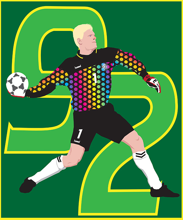
EURO 92 – Danish Fairytales. By 1992 I was both taller and even more obsessed with football then ever. Rather than growing out of Panini football stickers with everyone else, I actually became a bit more avid collector, and with a small dinky little tournament like the European Championships that wasn’t too hard. I pored over that Euro 92 sticker book like it was the Bible, but it was better than the Bible, because it was shorter, substantially less confusing and had pictures of football players in it. I could write a whole book about my life and thoughts at the time of Euro 92 (same with Euro 96) but that would be longer, more confusing, and probably contain more pictures of kits than players. I was sixteen, the age at the edge of the world. I am pretty sure I watched every game; school was out, as it was by then for all sixteen year olds, so there was more free time. I would wander about, go to the library to read language books, listen to music, play guitar, see friends, draw, occasionally work as a waiter with my mum, go down Carnaby Street to the old Soccerscene football shirt shop, and obsess over football. My GCSEs were all done with, the final year of top-flight football before this new ‘Premier League’ started was over (I went to Lineker’s last game for Spurs at White Hart Lane), and the long, long summer beckoned. I remember going camping overnight with friends up in Stanmore, and even there I would bring my Euro 92 sticker album to read, when we weren’t firing air-guns at tin cans or trying to explode cans of beans on a camp fire. I would go regularly to a youth club at the Annunciation in Burnt Oak with my friend Terry, that’s where we would watch many of the games of Euro 92. The sticker album had all eight teams, plus two more, Denmark and Italy. They were the substitute teams, in case two of the qualified teams, CIS (formerly the USSR, kind of in the process of imploding) and Yugoslavia (on the verge of imploding) had to pull out. CIS managed to hold it together, though not with the beautifully insane kits they had in the sticker album (still a holy grail kit for me), but Yugoslavia started falling into chaos that year and were not able to take part. So, they called up Denmark, two weeks before the tournament. I was pretty disappointed, as Yugoslavia were the team that I was most looking forward to seeing, they really had the most amazing squad of players. Still, Denmark were always fun, and they did not disappoint. Their Hummel kit was like 1992 personified, baggy with unnecessary zigzags, carnivalesque stripes on the arms, and while Danish legend Michael Laudrup couldn’t play, his younger brother Brian became a real favourite. The star though was the red-nosed giant in goal, Peter Schmeichel, who wore a rainbow coloured kit that by the standards of the early 90s keeper kits was quite restrained. This was the last tournament before the backpass rule came into effect banning goalies from picking up passes from their own players, and Denmark milked every last ounce out of the old rule. This was the tournament that was Lineker’s farewell, but England, under the often maligned Graham Taylor, didn’t do so well and lost to the hosts Sweden, with Lineker being subbed off when England needed to score. Denmark though, they rode through on a big Viking boat shaped wave, and in the final they faced the old foes of Germany (playing as Germany for the first time since reunification), dispatching them with a John Jensen goal. “It’s like a fairy tale!” people said in the youth club while we watched. “It’s just like a fairy tale!” I hated that particular cliche even then; I hated most cliches, to the point of being a complete cliche myself. I couldn’t remember any fairy tales in which a ball kept getting passed back to a goalkeeper until the other team got bored and lost. Except the classic Jack and the Timewasting Back Pass. After this, if a goalie picked up a backpass he would give away a free kick, and the Age of Fairy Tales was ended. I was sixteen. Later that summer I went to Devon twice, first camping with that youth club, the second with my family; when we went to Cornwall for the second half of the trip, my parents were arguing so much that I ended up ditching them (I was sixteen, so already at the age I could just do that) and went to spend a few days with my old schoolfriend Kevin, who had moved to Devon. I also got my GCSE results – good in Art and German, not great in everything else, but enough to start A-Levels.
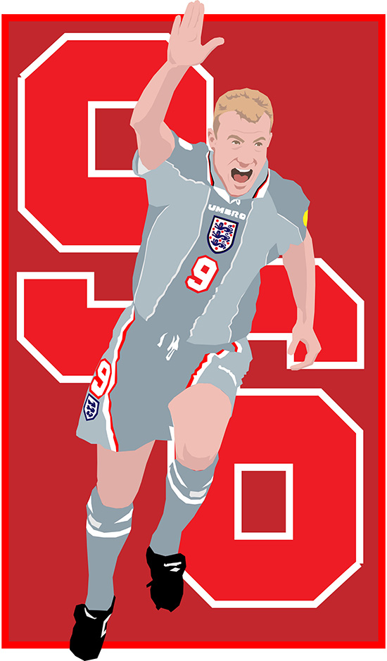
EURO 96 – Coming Home. The summer of 1996 was brilliant wasn’t it. You know it was. If you were in England, this was a great summer. The sun was out, and the Euros were being held right here, at home, football was coming home. For me, 1996 was one of those years that you feel your life turns on. I did my A-Levels from 92 to 94, and they didn’t go so well. By the time the World Cup USA 94 came around, I was done with school, done with it all, really. I loved the World Cup, but little else. By the time Euro 96 rolled around I was a different person, much more positive and upbeat, feeling fantastic. In the summer of 94 I decided that rather than go to a crap art college and paint badly until I got slightly better, I would go to a sixth form college and do a new set of A-Levels, including English, where I’d learn to write. Best decision I ever made. I made great friends, I was working part-time, I got into music again, I started exploring across Europe, the world was full of possibility. It was the height of Britpop, Blur and Oasis, Pulp, Elastica, Supergrass, er, Shed Seven. It was nearly the end of Tory Britain (until much later). In 1996 when I was at the end of my second A-Levels, excitement about the Euros was everywhere. This was a bigger tournament – sixteen teams instead of the previous eight – with exotic new teams like Croatia and their pizzeria-tablecloth shirts. At the time I was regularly going to the Hellfire Club and the Intrepid Fox in London, places full of leather-bound heavy metal rockers, among whom I was the only one wearing a football shirt, yet not being in any way out place; I also remember meeting up with friends at the Queens Head pub in Wood Green to watch a couple of games. What a tournament. Gazza’s goal v Scotland, with the dentist chair celebration. Most of all I remember working at Asda, in the coffee shop, on Friday evenings and Saturday afternoons. I had a little handheld portable TV (honestly, with a huge aerial) that I would sneakily watch the games on while filling the dishwasher. There was a guy I worked with called Lee, Arsenal fan but we got on really well, and on the day of the England v Spain quarter final he had to work in the kitchen upstairs, so we couldn’t sneakily watch the game together. So we would be on the supermarket phone to each other, I would be updating him on things as they happened. This is before the age of mobile phones and instant text updates. The penalty shootout came, and well, we knew that was that. But England won it. I called him up, huge cheers down the phone. I do remember going out that night, to the Hellfire Club, and pogoing up and down until the early hours with my friend Andrea (I know I bruised a rib), because the next day my uncle and I went with Andrea to see the Sex Pistols homecoming concert at Finsbury Park. My hair was longer, curlier, the sun was hot, the crowds were sweaty, and there was a big cheer when we heard Coratia had equalized against Germany, followed by a big sigh when Germany scored a winner, meaning England would play them in the semis. But we were jumping up and down to the Buzzcocks, and Skunk Anansie, and Iggy Pop, and then the Pistols themselves. My uncle Billy had got me into the Sex Pistols when I was 13, and we had waited our whole lives to see this. That day is one of my best memories. Billy died in 2019. A few days later, the semi final. I remember watching it at home, but I don’t actually remember who with. My dad probably. England wore the amazing grey away kit, designed to look good when worn with jeans; Alan Shearer, the best goalscorer in the country, scored first, and early. That illustration is of him celebrating. “It’s Coming Home, It’s Coming Home…” Germany scored soon after, Kuntz. (Sorry, that’s the player’s name). England were so close to a winner, but it went to penalties. It always goes to penalties. I’m sure I was in the kitchen, unable to watch. I’m never able to watch. And…they lost, at Wembley, with the current England boss Gareth Southgate, fresh-faced and innocent back then, missing the decisive kick. I still feel that. That was the feeling of that amazing 1996 year turning into a different year. At the time, I was dating an Italian girl who lived near South Kensington but worked at one of those amusement arcades near Leicester Square. Since she worked so late (usually until about 11:30pm) I would often meet her after work and we would spend time going out to the various rock clubs in Soho until the early sunrise hours, Bar Italia before the night bus. On the night of the semi-final defeat I got the tube down to meet her, I wasn’t in a great mood, feeling a bit glum. Football does that to me. Anyway at about Euston or somewhere these four boozed up English lads got on my tube train and sat around me, clearly also unhappy with the score. They decided to start singing at me, I’m not sure why, I suspected they thought I was German (that has happened before), but in retrospect it was probably because they were just stupid. I wanted to say look lads, leave it yeah, I’m as pissed off as you about the footy, but I just tried to ignore them. They definitely sang songs about the war to me, again because they either thought I was German or that’s just what a lot of England football louts do. I’ve said before, I usually support Ireland, but if England are there with no Ireland, I’m all for England, but it’s always the hooligans, the xenophobic louts that ruin it. This was a summer of positivity, feelgood, forgetting the years of Ing-Er-Land No Surrender thuggishness that had too often spoilt the party, but here they were. We pulled into Leicester Square and I got up to leave while they still sang intimidating songs at me. As I turned my back one of them grabbed my backpack and gave it a heavy shove. I nearly fell onto the crowded platform. At that point the Burnt Oak side came out and I turned right back around at them, standing in the doorway facing them all off with a barrage of “yeah come on then, off the train now, all of ya, come on!” Plus a few choice words of Anglo-Saxon origin. They stayed where they were, stood on the train. I glared at them as the door closed. Apparently that works. I was a skinny wretch with crap eyesight, but you know how invincible you feel at 20; I also knew that if they had stepped off the train, I probably couldn’t have taken all four on at once, but I did know all the quickest shortcuts around the station if I needed a speedy getaway. It turns out there was violence that night after the game, in Trafalgar Square most notably, as people took out their frustrations about a football team losing a penalty shootout on, I don;t know, the pigeons? I can’t remember us going to any rock clubs that night, I think we just had consolation ice cream, but that’s how Euro 96 ended for me. Oh right yeah, Germany beat the Czechs in the final with a Golden Goal. I’m not drawing bloody Oliver Bierhoff.
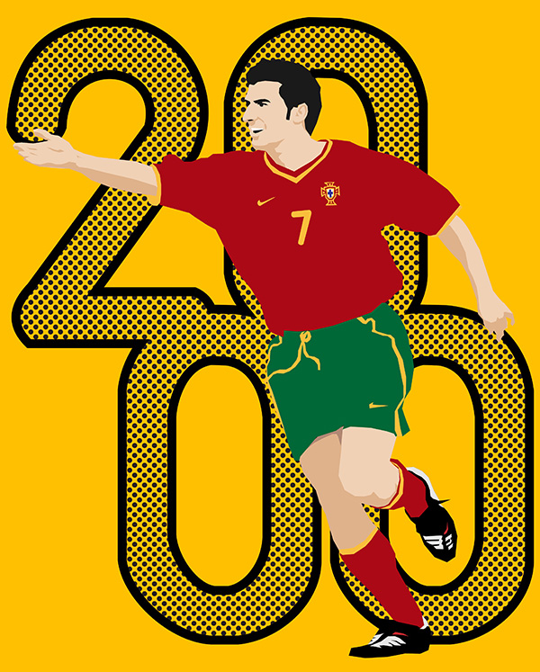
EURO 2000 – A Figo For Thee. In the autumn of 1999, two years into my French and Drama degree at university, I went to the city of Charleroi in Belgium for my Year Abroad. That was a required part of the French degree, and it gave me the opportunity to improve my French, albeit with a Charleroi accent. Charleroi was a special place; I’m not saying it’s the worst city in Belgium, but that’s what other Belgians say to me. I like it, probably because others don’t. It was rainy, gloomy, industrial, worn down, but it was also the place where England would be playing two matches of Euro 2000, a tournament held jointly in Belgium and Holland, and where I lived was right across from the stadium. I could see into the Stade du Mambourg from my 13th floor bedroom window. It was great fun being in Belgium during this tournament. There were lots of nationalities living in Charleroi, so every time one fo them played you would get locals from that country riding their mopeds or cars around town honking their horns and waving their flags, it was just what they do. the biggest groups in Charleroi, which is an old mining town, were from Italy (mostly Sicily), and Turkey. When Italy won a game, it was a huge party. When Turkey beat Belgium, it was half a huge party. The staff in the bar where I used to drink and watch the games were so pissed off at losing to Turkey that they just took away the TV and closed the bar. He did something similar when Arsenal lost to Galatasaray a month earlier. So, I drank up my beer and went over to the Turkish kebab place Chez Raoul for some food to celebrate with my very happy Turkish friends. I used to get kebabs there all the time and they were always very friendly to me. I was 24, teaching English at the Universite de Travail, living on a diet of frites in sauce, mitraillettes de dinde (turkey kebabs), chocolate, and Belgian beer. I didn’t have a lot of friends, a few people I would sometimes meet up with, I’d watch football with my neighbours from Africa (in Euro 2000, my friends only supported the black players, even if they didn’t know the names – “le noir! le noir!” – with the exception of Paul Scholes, who they would cheer for in my honour, because he had red hair. Every time he would touch the ball, they would cheer “le roux! le roux!” On our floor, I was “le roux”, and I came back from Belgium speaking French with a bit of a Congolese accent. My favourite bar was La Cuve A Biere, a little place near where I lived, always warm and welcoming. In the colder months I would come in, my glasses would steam up, and by the time I got to the bar and wiped them clean there would already be a 25cl Maes beer waiting for me on the counter, and maybe a little bowl of spiced cheese. I watched England’s first game on their little TV. That one was played in Holland, where there was none of the typical England fan trouble, probably because of the calming effect of the local produce found in Holland. (Spoiler alert, Belgium is more famous for quite strong beer, so that calming effect was a little bit gone by the time they reached Charleroi). Anyway England were playing Portugal, and England were going to win. Scholes scored first – “le ROUX!” followed by the curly haired scouse wizard McManaman. And then Portugal came to life. The man of the moment was Luis Figo, a handsome man of a man, and that’s who I’ve drawn here. I know this was the tournament of France, of Trezeguet and Zidane, but for me the main man of Euro 2000 was Figo. What a man, look at him. “A Figo For Thee” ran a headline, quoting Shakespeare as you do, rather than “‘Ere Figo, ‘ere Figo, ‘ere Figo” or “Figo-ing Home…” etc. England lost 3-2, but that’s ok, they were playing Germany next in Charleroi. The England fans arrived in town the night before. As I said, every time a country played and won its fans would ride around town honking car horns, everyone got along, it was all good natured. Until England showed up and spoiled the party. A large bunch of lads, singing “With St George In My Heart Keep Me English” and “No Surrender To The IRA” (which wasn’t really going to be an issue in Charleroi). There had been a lot of talk before the tournament as to whether bars would be made to close up when England came into town to prevent drunken hooliganism (“la maladie anglaise” as it is known), but in Charleroi they just opened up stalls in the street selling beer. The locals were quite amused at the prospect of these English coming in. Having witnessed the chaos of the Charleroi carnival, they laughed in the face of drunken idiots. Well these ones on that Friday night up in Place Charles II decided that the French fans who were celebrating in their cars were doing it to wind up the English rather than celebrate their win. I was down there, I watched it all unfold (I had gone down with one of my Congolese neighbours, who was looking to sell some tickets for the game and needed me to translate). A few lads started to throw chairs at passing cars, then a few more threw beer, and the odd table. There were non-violent fans too of course, one man I spoke to was there with his young daughter and looked really disappointed. After a while I left them all to it and went home, not really wanting to be in a riot.
The riot as it turned out was the next day, before the match itself. I was actually getting out of town that morning to spend the day in the countryside with some friends, coming back later to watch the game with my neighbours. Charleroi was a little messy, but it was always a bit messy so nothing new there. England fans were poring into town in their droves, singing and cheering, and trying to start a fight with a couple of Germans who were just ignoring them. When I got off the train back into Charleroi later that day, the sight of thousands of English fans packing the town was quite jaw-dropping, and I wasn’t sure I’d make it home in time to see the game. So I went through the back streets and short cuts, I always know those. I was nervous – despite Charleroi’s (deserved) reputation in Belgium, I had never been nervous there, until I saw this quite volatile looking crowd. It was nearly kick-off time, so I found a little cafe I knew would be open (it was) and watched the first half in there. Next to me was an English bloke the size of a hill troll tattooed with all sorts of patriotic fun. Did I still look as German as I did in 96? I really didn’t want England to score while I was in there. At half-time I dashed uphill to where I lived, and watched the second half in the common room with my African neighbours. Shearer scored, and there were many celebrations. From me anyway, my neighbours didn’t care about this Shearer bloke. They told me that during the day while I was in the countryside, there was a big riot of England fans in the Place Charles II, much bigger than the night before. I believed it. This time the Belgian police had brought out their favourite weapon, the tank-mounted water cannon, knocking the chair throwing ing-er-landers all over the place. After the violent element had been routed, and England had won the game, the rest of the night was a massive party with all those who were left. I went into town with my neighbours, and ended up meeting a lot of fun England fans, and showed them all the places that were still open, mostly the typical old-man taverns of the sort that never actually closed in Charleroi, and the best frites, which of course are from Robert La Frite. Many were waiting up all night for the first train to the ferry in the morning. I made friends with a guy from the north who was an amateur boxer, and I helped him get his mobile phone back when it was half-inched by a couple of Tunisian lads (who we also made friends with; I still have a photo of me with these random people). It was probably the most fun I had in Belgium that whole year. By the time of the second match, my friend Jacki from the UK had come to visit; England lost to Romania and went out, it was a shame, but then I moved back to London and watched the rest of the tournament there; France won the final, a game I watched at an upscale pub in trendy Notting Hill, a million miles from the grimy soot-stained bricks of Charleroi.
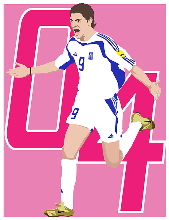
EURO 2004 – Hellas Raising. My wife is American; we met in 2002 (France), got engaged in 2003 (Italy), got married in 2004 (Las Vegas). 2004 was a year of wedding planning; 2005 was a year of moving-to-America planning. In 2004 we lived in Hornsey Lane, near Archway. As I look back on each chapter, at each Euros, my life is at a very different stage from the previous one. I’m not going to go to Euro 2008, but that was vastly different again – living in California, parent to a new baby, watching the games in Spanish. In 2004 though I was living the last years of my London life. I worked at a bookshop in Finchley, called the Finchley Bookshop. I worked downstairs in the office, trying to pay their invoices, and there were a lot of invoices. I remember before the Euros began, my wife’s office organized a sweepstake among their staff, and my wife had to pick a team randomly. She picked Greece. No chance of winning then. Spoiler alert, Greece did win. They did ‘a Denmark’, but it was better than a Denmark, because they had to beat more teams. They beat the hosts, Portugal, the favourites, twice. They beat the France of Zidane, 1-0. They beat the Czechs of Nedved, 1-0. It wasn’t pretty. The players weren’t fashionable. I think the fairly boring template adidas kit they wore didn’t help, it was unlike the fun outfits worn by the back-pass masters Denmark. They didn’t beat the perennial mechanical winning machine of Germany, but the golden hopefuls of Portugal, the team of the man, Figo, and the new young stepover star Cristiano Ronaldo. This illustration is of the winning goalscorer, Charisteas, a man so unfamous I cannot even remember his first name. My wife won twenty quid from that Greece win, lot of money back then. You could get eight pints for that much; be lucky to get three now, maybe four. While I remember watching the final and many of the other games at our small Crouch End studio flat, one of my main memories from that Euros was going to a packed pub in North Finchley on a hot Thursday afternoon with my friend Tel, and watching England beat the Swiss 3-0, and everyone falling in love with this young Scouse kid, Wayne Rooney. He was so brilliant back then, like he was made of electricity and freckles, lightning fast but made of meat, like a power chord in a milk bottle. If you think these metaphors are bad, I remember the newspaper headlines back then, all having some sort of pun on the ‘Roo’ part of his name. It’s strange, I find it hard to remember that well now, those few years living back in England before we came out here. Our Vegas wedding later that year was obviously the big event, and 2004 is one year where I don’t measure my life by the European football championships. I do remember my stag night out in Chalk Farm with all my best friends…well, I remember most of it. I started a masters degree in medieval English at King’s, so spent a lot more time down in the library in central London, reading medieval texts and journals about Anglo-Norman. We started the process for me to become a Permanent Resident ahead of actually moving out here, which we did a year later. By the time the next Euros came about in 2008 we were three years here, parents to a newborn baby, now a teenager with whom I watch the Euros and World Cups. He is just a year older than I was when I watched Van Basten’s volley in 1988. I’ll tell you as well, he’s a lot better at those than I was.
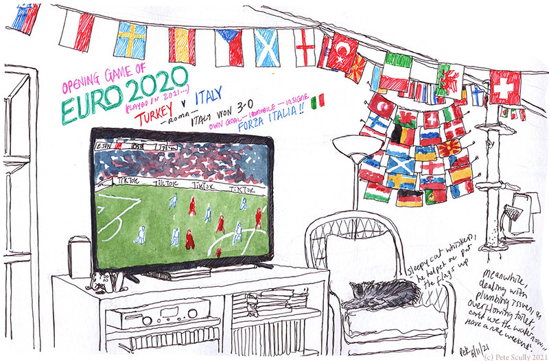
So Euro 2020 starts tomorrow, here in 2021, Italy v Turkey, in Rome. England play on Sunday, and Ireland aren’t in it so I can cheer for England (though I’ll be wearing the Scottish shirt as well). I hope it’s fun, I hope I’m not too sick of football after this year. I suspect that in twenty years when I write another post I’ll remember this one more for the life events around it, what with it being postponed from last year because of the, you know, historic global pandemic. I wonder what player I will draw? Phil Foden? Gareth Bale? Kylian Mbappe? Or a completely unexpected Charisteas type unknown, like Elif Elmas of North Macedonia?