It turns out the next national park we would visit was actually Zion again, but a completely different (almost completely separate) part of the park called Kolob Canyons. We were on the long long drive from Bryce Canyon to Las Vegas, so this was a good place halfway to stop for a while (but that was a long journey across the desert, and an otherwise boring busy freeway). We stopped and went to an overlook where you can see the panoramic vista, with arches like huge wheels forming in the rich orange rock; I used that new Daniel Smith Aussie Red Gold to bring out the colour in this one, that paint is a bit strong (and a lot more golden yellow than the reddish brown that comes out of the tube, it’s a way stronger pigment than my other paints). We stopped in at the Visitor Center on the way in, where I got my souvenirs, but we didn’t have time to do any hiking, we were off to spend the night in Vegas.
Tag: national park
Bryce Canyon
It was a fairly long drive across southern Utah from Zion to Bryce Canyon National Park, most of which was filled with bluish grey scenery with mysterious mountain backdrops, until we passed through an area called Red Canyon, where the rocks suddenly took on a bright reddish orange, and we had to drive through two archways in the rock. Snow was falling, and got heavier as we pressed on to Bryce Canyon City, which is not exactly a City, more of a village, but one that has an excellent big hotel and restaurant called Ruby’s Inn. Though we stayed across the street at another nice hotel, we had dinner at Ruby’s both nights, hearty all-you-can-eat grub in a cowboy setting. We were spending just one day hiking Bryce Canyon, and while the landscape was covered in snow, it was another blue sky day for our exploring. It was busy, and not easy to find a place to park, but we started out at Sunrise Point, where my son and I hiked into the surreal landscape of the Queens Garden. Bryce Canyon is famous for its distinctive ‘hoodoos’, tall rock formations that look like the surface of an alien planet. While hoodoos exist elsewhere too, Bryce has the largest concentration of them, and to look down upon the valley from the plateau is like looking into an impenetrable maze. The trail felt like going on an adventure, and as we got deeper in the path got muddier and muddier. We had special metal devices for our boots to give extra grip, but our boots were absolutely caked in orange mud when we were done.
I forgot to bring my sketchbook with me, which was unlike me. As my wife didn’t come on the hike into the steep valley, she walked along the rim, before heading back to the hotel to get some snacks and pick up my sketchbook. The drawing above is one I did afterwards at the hotel, I really wanted to catch the unusual shapes in this place. The sketch at the very top, the distinctive and famous ‘Thor’s Hammer’, I drew quickly at the trailhead when I got my sketchbook. I did want to try to draw a panorama of the landscape though, so I drew the whole scene below from the Sunset Point – though in pencil outline, I did start some of the ink but decided to go and hike along the rim a little more, so I ended up drawing most of that at the hotel too. We loved this place. It’s not often you get to see a place so spectacular. It took a long time to get there, but these are the parts of America you just have to see to believe. And it was so red!
The Queen’s Garden merged with the Navajo Trail, which took me and my son through more muddy oaths and snowy vales, before leading us upward in a steep zigzag, and passing the aforementioned Thor’s Hammer. Here it is again, below. You really get the sense of mythology here, and it reminded me of the Valley of the Mystics in the Dark Crystal. We felt pretty great when we made it back up to the top, that was a good achievement for us both. We watched over people starting their trail wearing nice new trainers, not exactly waterproof hiking boots, and we were like, good luck with that. It took me a good while to clean my boots.
You can find out more about Bryce Canyon here. It’s another National Park off our list! We walked along the Rim Trail looking down into the mass of hoodoos; some trails were not open due to conditions, but we were not overdoing the hiking that day, more taking in the amazing scenery. Still, it was busy and so we headed to the gift shop/information centre so I could get all my usual postcards and stickers and pins, and get my sketchbook stamped. I wonder which national park we will go to next?
Zion (part 2)
After our day one post-hiking rest at the hotel, we walked down to Zion Village to have dinner at the pub-restaurant there. We had to wait a while for the table, which = more sketching time. I sat and looked at the huge ridge that acted like a giant wall to the geological theme park beyond it. Dinner was nice, I had a refreshing local beer, and we got a good night’s sleep. More hiking next day!
We slept in a bit more the next day, and when we got up to hike the park the lines for the shuttle bus were already so long that if we’d waited in line it would have been nigh on three hours before we got a ride, that’s what people were saying. Worth the wait? Maybe, but probably better just to start out earlier. Zion is ridiculously busy. Most people I’m guessing were headed out to the Narrows, looking at the number of waterproof outfits, but there are a lot of interesting hikes in Zion, ranging from “Easy”, “Moderate”, “Difficult”, “Strenuous”, and “Turn Back Now All Ye Who Dare Enter”. The last category I think is saved for the famous Angel’s Landing, which is on the Scout Lookout via the West Rim Trail, and you need a permit for that bit. This morning however we were not taking the shuttle bus, nor hiking up no strenuous and terrifying trail, but walking the easy peasy lemon squeezy Pa’rus Trail, which is a simple pave trail starting at the Visitor’s Center and following the Virgin River through some stunning scenery. The main hazard was from all the e-bikes whizzing by and rumbling over the bridges, but that was much less hazardous than a walk across the UC Davis campus when classes get out. The immense cliffs around us made us feel tiny. It was great to walk through, and we caught a shuttle back to the starting point again when we were about done, but I definitely wanted a bit more hiking, and to see things from higher up. So when my family had a wander around Springdale, I hiked the Watchman Trail (moderate).
The Watchman is a tall mountain that stands sentinel near the start of the park, but this trail wasn’t taking me up there, rather going up a decent uphill trail that landed at a plateau with an amazing view of the Watchman. Who Watches the Watchmen? I tried not to talk to myself on the way up in Rorschach’s voice, it’s been a while since I read that book. I remembered all the exploration of this area I had done in the Horizon game. The few clouds in the otherwise blue sky were comforting, but not threatening to get me wet. It was a nice hike and when I got to the top I sketched the scene above with the tree in the foreground, trying to get the pink-hued colours and the fluffy sky, and then did a quick pencil sketch of the Watchman itself (also above, which I coloured in later). It was a long hike down, and at the end I spent a bit of time in the Visitor’s Center shop, always one of my favourite things about visiting the National Parks. I always get way too many little souvenirs, postcards, pins, stickers. We had to get a move on though, because we were off to Bryce Canyon that afternoon, and it was a long old way. See you Zion, that was a lovely place.
Zion National Park (part 1)
For Spring Break this year we took another trip to southern Utah, to visit some of the beautiful national parks down there. In 2021 we had been to Arches and Canyonlands, staying in Moab after a very long drive from northern California; this time we flew into Vegas and drove to Utah from there, across the desert, passing through a little triangle of Arizona. We were headed for Zion, one of the most famous national parks in America. We stayed in Springdale, a long narrow town that hugs the Virgin River, and our hotel was footsteps away from the park entrance. We are racking up the national parks now, over the past few years. Our room was nice, with a view of red-rocked mountains right from our bed. Zion is one of the most popular parks, and the crowds can get a bit heavy. There is a shuttle bus from the park entrance to get to most of the trailheads in the long canyon, and the lines for this can honestly last 2-3 hours if you get there at the busy time. We went down early, not too early but it was about 8:30am, and there weren’t many people there yet. We got on the first bus, although it’s fair to say the bus was still full, mostly with hikers wearing full waterproof overalls and carrying long thick sticks of wood. They would hiking The Narrows, a well known trail through a series of narrow slot canyons down which you must wade in the cold waters of the river. Usually that might be up to your ankles or your knees; at this time of year it’s more like up to your chest. We weren’t doing that this time, although seeing everyone getting ready for it, I was kind of feeling a little like actually I wouldn’t mind doing that. Then I had a vision of tripping on a rock and going under, and I kept thinking of that one “Charley Says” where the cat falls into the canal and it all gets very sinister. “Charley says, never go into the Narrows when it’s really deep ‘cos you might sick from Toxic Cyanobacteria Bloom.” You might have to be British and from a certain time period to understand Charley Says. Anyway, the Narrows can wait for another time. We got off the bus right at the end to stop #9, at what’s called the ‘Temple of Sinawava’. I drew this sketch above from right there where you pick up the bus. We walked along the Riverside Trail, which leads down to the Narrows, and it was through a deep and pretty gorge, a fairly easy hike.
The whole thing reminded me of the big valley where you have to spend a lot of time hunting machines and fighting bandits in the brilliant game Horizon – Forbidden West. It turns out, that whole area (known in Horizon as ‘The Daunt’ is basically Zion in the far future, so as I explored the park for the first time ever, I felt like I knew it really well, it was all so familiar. We got the bus down to stop #6, The Grotto. We hiked up the Kayenta Trail up to the Emerald Pools; the Middle Emerald Pool wasn’t all that, but it was a steep climb up to the Upper Emerald Pool was worth it. It wasn’t really Emerald exactly, more brown, as I think every single person up there pointed out, like it was the most original comment in the world. Having started out quite chilly in the morning, it was turning into a pretty warm day, with blue skies and sweaty legs. I stopped at the top and sat by the pool, which had a waterfall coming into it from a sheer cliff face, and I sketched this large almost cubic rock that was wedged into the waters. I then made my way back down, and rejoined my family to look around the dramatic sweep of Lower Emerald Pool. I definitely recognized this from Horizon. We ate our packed lunch and I did a quick sketch of the rocks above it (see below).
We eschewed the busier trail on the way down (“eschewed”? I don’t talk like that) and walked down a less populous route, peace and quiet, towards the bridge. Of course, the bridge was closed, and it was a good couple of miles before there was another crossing. I mean look, in the video game I could just hop across the water and not even get wet. Life isn’t a video game. In video games, you spend most of the day looking at a screen and pressing buttons, while in real life…more drink! (with cheers to Father Ted there) We walked a long way, being passed at one point by a big group of people on horseback being led by a real-life cowboy with spurs on his boots. I wish I had some spurs, I don’t know what I’d need them for though. I’d wear them on the bus to Wembley just to get a cheap Instagram laugh. We did rest after while, and I did another sketch, see below. I drew this with the brown fountain pen, which was really nice for drawing Zion. I also stamped it later that day at the Visitor’s Center, which for some reason had the wrong date on it. We walked further until we crossed a meadow of long grass and tree branches, and saw a big deer hiding. After going through all the deer puns I could think of, which was surprisingly not many, we managed to find a bridge to cross and caught the bus back to the hotel, where we got straight into bed for an afternoon lie-down. Within minutes of hitting the pillow and daydreaming about maybe hiking the Narrows the next day, a massive rainstorm came into the valley and washed all those silly ideas away. It was nice to be inside and in bed, I can tell you.
More to come!
Pa’ia, `Īao, and Up-Country to Haleakalā
It wasn’t all beach time in Maui. I mean it mostly was, plus pool time, plus playing the ukulele looking at the ocean time, plus expensive cocktail time. There was a lot of looking out at the sunset like Luke Skywalker as well. On one of the days though we hired a car and went off on an adventure. Four years ago, we had done the Road to Hana, or at least as much of it as we could fit in in the short December daylight. This time we were going Up Country, but we did stop off in one familiar place, the surfing town of Pa’ia. We were going for lunch at the Pa’ia Fish Market, an evidently popular place with a long line out of the door. While my wife and son lined up, I went a bit further down the street to start a sketch of Tobi’s Shave Ice, where we had been back in 2019. Page 1 of a new sketchbook. I loved their shave ice when we went before, and this time did not disappoint either, when we popped in after lunch and after shopping in the little stores. Pa’ia is an interesting little town, a lot of traffic rolls through though, so it doesn’t feel peaceful. We didn’t go to the beach this time. For the best; while we were getting lunch, a fire truck zoomed through town, and it turns out that a local surfer was killed by a shark out in the waves at about the time we came into town, we heard later on. It was sad news, and the beach was closed off. From Pa’ia we drove uphill and up country.
Before we went to Pa’ia though we visited the ʻĪao Valley State Monument in West Maui, a really interesting tropical park with deep green valleys and a dramatic promontory called the ʻĪao Needle (Kūkaʻemoku), which I did a very quick sketch of above in pencil and paint. The needle is said to be a huge phallic representation, whatever that means. The valley has been the burial ground for many big nobs, that is local nobolity and even one of the Hawaiian kings. There was a particularly bloody battle here in 1790 called the Battle of Kepaniwai, between Kamehameha the Great and the Maui army of Kalanikūpule, but Kamehemeha won and the islands were united. It was a really interesting and beautiful place to spend a morning, and covered in a blanket of tropical cloud. 
Anyway after we left Pa’ia we were uphill all the way to Haleakalā. We stopped off on the way in a small village called Makawao, where we looked around and found the Maui Cookie Lady. This was a tiny little store, so small only a few people at a time could go in, while everyone else had to wait outside. (That reminded me of the newsagents near my school, which only let two school kids in at a time.) That waiting time gave me a chance to get the sketchbook and brown fountain pen out, and I drew as quickly as I could. Eventually my wife emerged with these two massive, well I say cookies, I thought they were cakes. I was less fussed about eating these massive cookies, but when I finally did eat some the next day, I was blown away. The one I had was some kind of chocolate one, and it was like a mix between a cookie and a brownie, but way better than either. It was one of the most amazing things I’d ever eaten. So if you are in Makawao, look out for the Maui Cookie Lady because she makes seriously amazing (and huge) cookies. 
We drove further up, up, up country, getting some dramatic views across Maui, our ears and eyes all popping. Then we hit the clouds, and the sunlight dimmed, and the roads twisted and turned in huge zigzags up the mountain. Eventually, the clouds melted off and we entered Haleakalā National Park. We bought a National Parks Annual Pass, because we definitely intend to visit some more this year. I’ve become quite interested in National Parks, and have collected pins and postcards from each one we’ve been to. Ok in the past few years, so far we’ve visited Arches (Utah), Canyonlands (Utah), Yosemite (California), Petrified Forest (Arizona) Grand Canyon (Arizona), and now Haleakalā (Hawaii). There are many more on the list. We are planning to visit Bryce Canyon and Zion (both Utah) later this year. The day was pushing along fast, but we were only in Haleakalā for one reason – to watch the sunset. A lot of people come to watch the sunrise, but I didn’t much fancy getting up at 3am to drive several hours up a mountain in the dark, and then not get a parking space. Sunset it was, and I have to say, we all agreed it was well worth it, a real once in a lifetime experience. We drove above the sea of fluffy white clouds for a while longer, like this was some floating island in the sky. We reached the crater and went and had a look, but we wanted to make sure we got a seat at the top table so we got back in the car and headed for the summit. Haleakalā – which means ‘House of the Sun’ in Hawaiian – is a giant dormant volcano, and the crater is an impressive sight as the shadows slowly drift across it. Legends say that the grandmother of the Hawaiian heroic demigod Māui was born here. I had to sketch it. There were otherworldly plants called ‘silverswords’ dotted around, a super rare plant that grows nowhere else on the planet except here. It was cold up at the summit, 10,000 feet above sea level, and we had to wrap up warm. There were a lot of people gathered up there, but it wasn’t too bad, there was sunset enough for everyone. I played my ukulele up there above the clouds. This is a sacred place for local people from Maui, and you can see why. There was a local man singing as the sun set, with his own ukulele, singing a local version of ‘Take Me Home, Country Roads’. Across the mountaintop are the space surveillance systems of the Observatory, which you can see in my quick pre-sunset sketch below. It was beautiful.
It was a once-in-a-lifetime sunset. I know the sun goes down every single night and pretty much always has done, but where you watch it from really makes a difference. 
Yeah Maui was pretty amazing. Big thumbs up from me.
the grand ol’ canyon
After leaving Flagstaff, we drove north through Arizona, watching the landscape continue to change. We passed through the Navajo Nation – our clocks automatically went forward an hour from the rest of Arizona time. It was interesting as we stopped off for a bit to eat as well, the indoor mask enforcement was a much more in place on Navajo land than in the rest of Arizona, it was more like California. The Navajo Nation covers a pretty vast area, the largest Native American reservation in the US. After driving through for a while, there was a pinkish glow to the landscape ahead of us, and it was clear we were approaching canyon country. As the road turned we would start seeing gorges open up, wow that’s quite deep, and they would start getting deeper and you could see that ahead of us was something big that we couldn’t see. We arrived at the Grand Canyon National Park by the entrance furthest to the eats, whcih was a pretty great idea. I was expecting something like we experienced at Yosemite – long lines of cars, massive overcrowding, a couple of hours sat in traffic, but there was none of that at all. In fact I was incredibly impressed at how uncrowded the Grand Canyon NP was. When we first arrived and caught our first real view of the Canyon itself, the scenery just blows your breath away, it takes your mind, it’s like nothing you could really believe. We were here before, 20 years ago, long before our son came along, so this was his first time. We started out at Desert View Point, taking lots of photos, getting the National PArk stamps in my sketchbook, and I did a sketch of the Desert View Watchtower (below), built by the architect Mary Colter back in 1932, inspired by the ancestral Puebloan people of the Colorado Plateau. We also sat for a while outside by the rim and just looked, while I sat on a ledge and drew the scene above. I could only paint the shadows – the colours of the Canyon are a bit overwhelming for a predominantly urban urban sketcher like me, but I wanted to try a bit of Canyon painting. There was actually some snow on the rim, and the weather was bright and sunny but a little cold still, and I still wore my nice warm scarf.
We drove further along the rim of Canyon to the Grand Canyon Village, where we were staying at a lodge right by the rim. Incredible location, we were lucky to get that. I caught the bus back down towards the South Kaibab trailhead. I was eager to do some hiking into the Canyon, and that was a pretty good trail to be taking on. The shuttle bus services at the Grand Canyon are amazing, all free, very regular, often with entertaining and knowledgeable drivers. I was going to be hiking alone down the South Kaibob trail as my family were resting up a bit, and I went about a mile or so down the narrow zigzagging paths until I reached Ooh-Aah Point. The temperature rose considerably as I descended – apparently the base of Canyon it is as warm as Phoenix, even if there is frost on the rim. I sketched at Ooh-Aah Point, making Eric Cantona jokes to myself (“Ooh-Aah Canyona”). I got a lot of spectacular photos down there, but you only get to see my sketches, because I’m not organized enough to find and post those too. The Grand Canyon is so deep, man. Looking down at the hikers below who continued down the trail was like looking at ants. It’s nearly 5000 feet to the bottom, where the Colorado river keeps on carving and curving, and a good ten miles across to the north side. While my plan was just to hike to Ooh-Aah Point (about a mile or so) before climbing back up again to meet up with the family, I did start walking down the path a bit further, as I was making good time on foot. Then I realized just how steep it was, and how hot it was in the sun, so I headed skywards again. The climb back out was considerably more strenuous – I can see how hiking the Grand Canyon is like mountaineering in reverse, where the hard part is the bit when you are tired. You have to be careful, and drink lots of water, and there is no water on the trail itself, you have to bring a lot with you. I was pleased to get back to the more shaded zig-zagging paths near to the top, but there were people who were just knackered all along the way. I got to the top again and it felt like an achievement. I do like a hike. As I neared the rim, I saw some people throwing rocks into the Canyon. Not just the youths, but their parents too. Someone else told them not to do so as it was dangerous, but they just glared and kept on doing it anyway. I had seen people down on the trail, hikers with kids, and if a stone thrown down had hit them it could have been serious. I was right above them so I shouted down in my clearest Burnt Oak, “OI! STOP THROWING THEM BLOODY STONES! THERE’S PEOPLE DOWN THERE!” I like to think it echoed around the valleys like the Supreme Being in Time Bandits or something, but they did stop. Fools are gonna fool.
We stayed in a nice little room at the Bright Angel Lodge, just footsteps from the edge of the Canyon. At night there were so many stars out my poor stretched eyes were popping out of their sockets. I love a bit of star-gazing. We slept ok, except for the noisy heating unit in the room, and I woke up super early before the sun came up and went outside to watch the day break, and of course do some early-morning sketching. It was pretty cold. I drew the small building near our lodge, the Lookout, which dates back to 1914. The Canyon was being filed with deep purple shadows and creamy orange light, but the sky was crisp. Hikers were already out, tenacious groups starting the Bright Angel Trail (that’s a hike I would like to do some day). I do get excited by all the hikers, it’s something I would like to do more of. The only thing is I like to sketch, so I probably need to hike with people that need to take lots of breaks.
After drawing this, I was starting to feel quite cold but it was still early, the family was still sleeping and I had another sketch in me. There was a fire hydrant perfectly placed not too far away. Rather than go on a little solo morning hike, I sat and drew this instead. And then…my paints froze. They were acting unusual, beading up in places, not acting how my watercolours would normally act in warm dry Davis. I tried paint more but there was frost in my paint tray. This has never happened to me, but I’d got about halfway through (I had painted the whole previous one no problem) before I had to go back inside to warm the paints up. I was quite pleased with that background though, but Grand Canyon painting is a whole ‘nother ballgame. Fire hydrants however, I know those.
On that second day we did do a lot of exploring, taking the shuttle bus out to the Hermits Rest, on the western end of the park, and did a mixture of hiking and shuttle-bussing back along the rim, taking photos along the way. I did start a couple of sketches, but just quick pencil outlines I never finished off. The one below was one from the sunset the evening before, by the Grand Canyon Village, I drew all the pencil and then added in the colour after.
This was an amazing trip and I’m so grateful to my amazing wife for arranging the whole thing and taking us everywhere, she has all the best ideas. We left the Grand Canyon and spent a couple of nights at a hotel resort in Scottsdale (next to Phoenix) where the weather was much hotter, I did no sketching, and we spent a lot of time going around the lazy river. I even saw a real life rattlesnake and a real life gila monster (not to worry, both were in glass cases in the hotel!). It was a nice trip to Arizona.
Yosemite Slam
It takes a long time to get into Yosemite, but what a beautiful place that valley is. You do have to take some lengthy twisty roads with terrifying drops down into deep gorges just one swerve away, and then when you finally reach the environs of the park and the rocks start changing from a dusty ochre to a stern granite grey you see the line of cars going in at geological speed and start wondering about Fast Passes like at theme parks, and then you realize the drop to the valley floor, that is the Fast Pass. We arrived in the afternoon on a holiday weekend, therefore specifically requesting trouble on the form. You need a reservation to get into Yosemite these days to, ahem, stem the crowds. We had one, as we were staying at the Lodge in the middle of the park. You could see cars going the other direction and you just know they had shown up without one. It took the best part of two hours to get in, and it was hot. When we got in, we had planned to do the Mist Trail hike first and then go to the Lodge, but you couldn’t park anywhere near the Mist Trail. We found a spot about two miles or so away and then walked in, backpacks with hydration packs on, stopping to take photos of the amazing views, admire the immense rock walls of the valley, and also to question What The Hell. It was packed. It was hot. By the time we finally reached the start of the trail we were hiked out. The trail itself was fairly steep and a bit narrow, but mostly just jam-packed with people. I know why they call it the Mist Trail, it’s not the spray from the waterfalls but the clouds of other peoples’ sweat you have to walk through. I made it as far as the first bridge by a waterfall and we headed back. Massive headache. On the way back though, we saw a bear cub! I’ve never seen a bear in the wild. Not that I wanted to get too close to one, it was on the other side of the road, just minding its own business, I think it was in the collecting food business. Then I heard a very loud whistle. It wasn’t mama bear because they can’t whistle. It was some tall American dude in shorts and a big stupid hat, getting out of his big stupid car and approaching the bear like it owed him money, or honey, whatever. He was whistling to get its attention, while also exclaiming “do you see the bear!” to passers by. “Yeah leave it be, mate” I said. The bear disappeared into the bushes. The man looked like he was going to follow it in to try to get a photo on his phone up close. I mean, I don’t wish anyone’s face to be eaten by a bear for being stupid, but seriously, you don’t follow a bear into the bushes. Big Stupid Man in Hat then turned round and went back to his big stupid car still exclaiming “did you see the bear” to everyone who had been distracted by his ridiculous whistling. I’m pretty sure you can be fined a lot of honey for approaching the wild animals in Yosemite like that, at the very least his picnic basket should have been confiscated. Anyway now I had something to write about on my postcards, we got back to the Lodge. Our room smelled as if someone had been smoking in it, which was pretty unbearable (I see what you did there), so we opened up the windows and ran all the fans. I did insist we close the windows at night though Because Bears. They love to sniff out the food, they famously break into cars, I saw a documentary about it, Gone In 60 Seconds I think it was. Or maybe the Fast and the Furriest. Anyway, well fed and showered, and well rested, and safe from bears, I got up very early next day and headed out into the park before the heat, while the family still slept, and sketched the magnificent Yosemite Falls, above. It was not super busy yet, and this was the start of the trails leading up to the Lower Falls. Stunning sight though, and the absolute drama of the scenery is hard to describe, and not easy to draw either.
This was our third National Park this year (after Arches and Canyonlands). The colour scheme was quite different; before the Utah trip I did actually do lots of practice sketching so that I knew how I would like to draw once I got there, what colour palette I would use, even what style of sketching would work best for quickest effect. I didn’t do that this time; I wish I had in a way, but then the greens and blues are always tricky bedfellows in my paint set. The Yosemite light is overwhelming, like I felt there was no way to capture the sheer epic-ness of it, but even on the hot day I stopped and gave it a go. The one above was very quick and done with pencil and watercolour, and I was pleased with it. As we walked through Yosemite Village I happened upon a familiar face, Robert Dvorak, a Sacramento artist and art teacher who has joined us many times on our sketchcrawls in Davis. I hadn’t seen him since a sketchcrawl just before the pandemic, but I recognized his distinctive hat, he was teaching a small workshop on sketching. He was surprised to see me, and showed his students my sketchbook. I left and got the Yosemite National Park stamps in my sketchbook, and we continued exploring. The sketch below was drawn while standing on the Swinging Bridge (it didn’t swing, but I guess there were lots of 1960s British hip fashion-followers there at some point. I wanted to catch the colour of the Merced River and the silent giants behind it; I did the paint first and then pen over the top, which I never really like doing, and I can tell as it feels a bit awkward from about the riverbanks up. My green paints feel a bit dry as well. Still as a quick sketch drawn while balanced on a bridge with people passing by behind me, hoping not to accidentally drop my sketchbook and paints into the river, I still like it. It was a hot day, we explored the non-uphill parts of the valley, took a lot of photos, and headed back to the car for a drive up to Glacier Point.
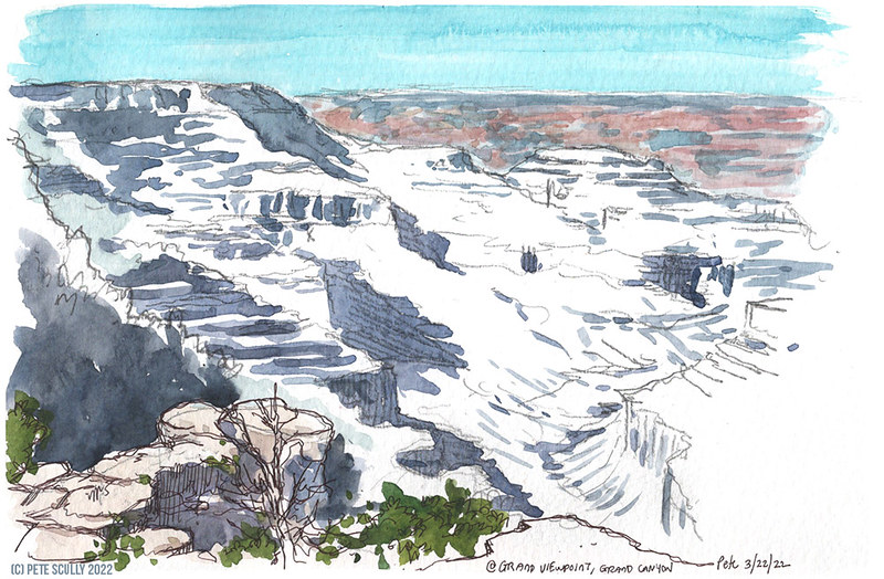
Glacier Point (where I did the sketch below) is about an hour’s drive uphill from the Yosemite Valley floor. It is an overlook with a phenomenal view of the whole valley. The way up was a little depressing, as much of the landscape had been affected by big fires in recent years. In anticipation of this unusually hot holiday weekend there had been a controlled burn on the valley floor, we had passed the smouldering logs on the way in, but this was more of a sad beaten wasteland. Still, despite the fact that the past few years have been worse than anyone here has ever known, exacerbated by the rise in global temperatures, in the California wilderness fire is the way of things, nature’s way of renewing the forests. Still, it’s hard to see. It was another twisting rollercoaster of a road up. We have been to Glacier Point before; when we married in 2004 we came to Yosemite for our honeymoon, and we have photos of us looking much younger looking out at the view which is dominated by the otherworldly Half Dome, which resembles the cowl of a massive stone ghost. We could just about make out people on the top, tiny atoms in colourful hiking gear. It’s a dizzying view. There were a good number of people up there, but not as packed as the Mist Trail. I took a little time to do a quick sketch of the scene, but this one I did not fill in the gaps later at home, I just left it as it was. At this time of year the waterfalls are gushing and plentiful; in the western US we are in the midst of a potentially catastrophic drought though, so I expect that by the middle of the summer those will be trickles, if even that. When we were here in September 2004 Bridalveil Falls was not even running; this time that bride was running like she had just discovered her new in-laws were all death eaters or Hannity fans or something. It would be nice to come back slightly earlier in the year when it’s not already so hot, and the rivers are still booming, but even just a fortnight before there had been snow around here so it’s hard to predict. Maybe just when there are fewer people, not on a holiday weekend, it might be more fun to hike the trails. It just takes so long to get here. It’s worth it though, this Yosemite scenery is some of the best on the planet. We took a lot of photos of amazing backdrops, and the light always seemed to be just perfect.
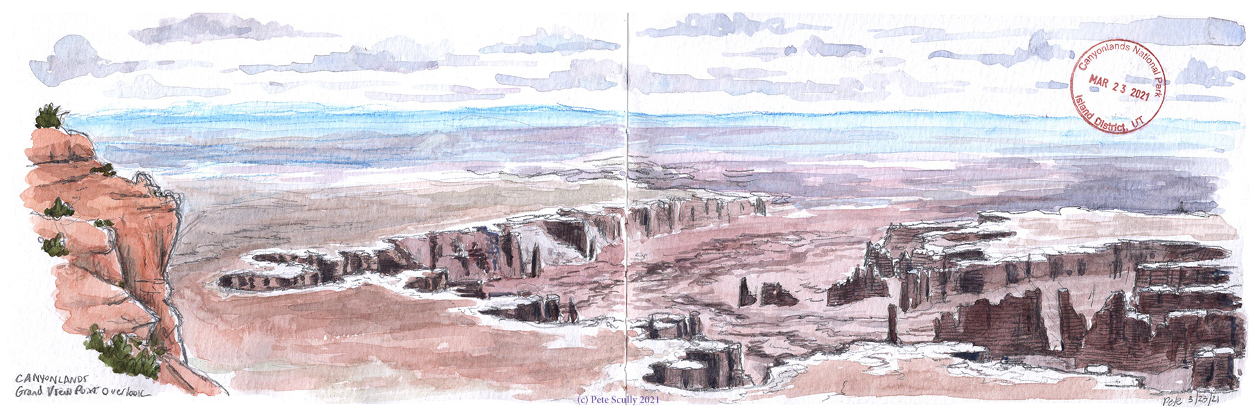
I didn’t draw El Capitan, and it’s not in this panorama, but that was another geological marvel we passed by in awe. El Capitan is really massive. When we got home we watched the documentary film Free Solo, about the bloke who likes to climb up rocks with no ropes or harnesses or anything. They call that “free soloing”. “Freeing Solo” is when you dress up as a masked bounty hunter with a thermal detonator and sneak around Jabba’s palace at night looking for your carbonite-imprisoned boyfriend, just so you can ask him “what do you mean “I know”?” (Seriously Leia, when Han asked “Who are you” you should have said “Someone who knows you” and slapped him one.). So the Free Solo guy (Alex Honnold) was pretty bloody amazing. The movie was so good, and it detailed his journey to becoming the first – and so far only – person to scale the sheer face of El Capitan free solo, bottom to top, no ropes or nothing. Incredible film I recommend you watch it. (I also recommend the Return of the Jedi “Leia Says I Know First” special edition cut). It made me think, we all have goals, some people’s goals might be something huge like climbing a gigantic cliff with your bare hands, others it might be just drawing a picture of those cliffs and it turning out alright, but it’s an inspiration to see someone work on their goal, have setbacks here and there, but not give up, to really do it. No matter how big or small your goal, go for it. The only thing I didn’t like about the movie was the song that played over the end credits, which had a chorus that went ‘Gravity’s a Fragile Thing”. I mean, it’s literally not. Gravity is definitely the thing you can rely on not breaking. It will break you. Those lyrics were a pretty fragile thing. Still, the film reminded me of when I went rock climbing when I was 17, I went about 25 or 30 feet maybe, with ropes, and was absolutely terrified. I felt that Gravity pulling me down, and I was myself a very fragile thing at the time weighing about half a stone dripping wet, so it juts blows my mind to see someone achieve a feat like that. Mind Blown.
And that was Yosemite. It was a long and winding drive back to Davis, and when we got home we decided against long road journeys for a while. We had 17 years between visits to Yosemite, and this was the first time since we moved to America. It’s a pretty long way, but it’s worth it.
Utah 4: Devil’s Garden
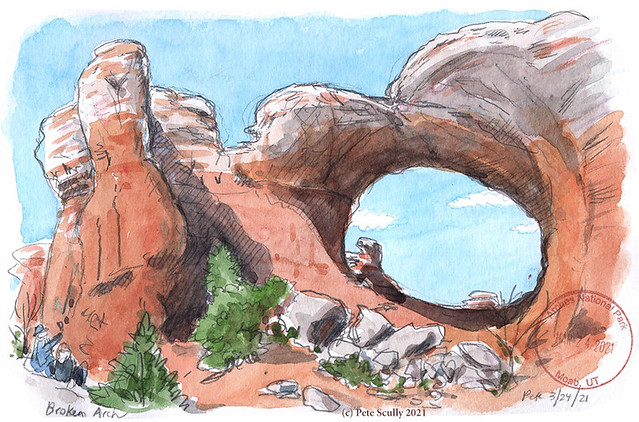
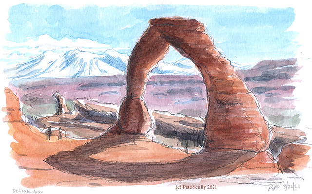
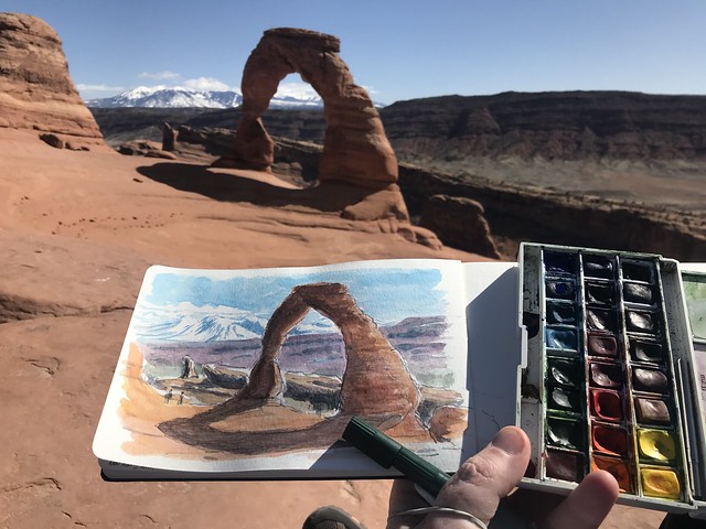
On the third day in Moab we returned to Arches and this time started our day by exploring the popular Devil’s Garden area. This place is packed with arches, and I’m glad we got there early because before long it was packed with hikers too. People like to do the Devil’s Garden loop, a seven mile or so hike that includes some tricky scrambles over rocks but gives some amazing postcard views. We didn’t do that whole thing, but just went part of the way in. The walk to the long and fragile Landscape Arch was really pleasant, a well-worn path through some short narrow canyons, easy to get to. My son had done a state project on Utah at elementary school a couple of years ago, the main reason we wanted to come and explore Arches with him, as he had made a model of Landscape Arch and wheeled it around the playground in the “parade of states”, this is a popular thing kids learn about at American schools. This particular arch used to have a bit more to it, and the trail would pass underneath it, but then about thirty years ago a large chunk of it fell off, so now you can only get so close, in case more comes down. I overheard a geologist say to his kids while I was there, “hey kids,” (I might be paraphrasing) “he kids, I’m a geologist and I think that more of that rock might come down. All it needs is an earthquake, maybe even a bit of wind, and that rock’s gonna tumble like a lizard in a blizzard,” (Yes I am definitely misremembering what he actually said, I think the Wild West scenery probably clouded my memory a bit). Below, that’s me sketching the Landscape Arch.
We didn’t go a great deal further along this trail, because it reached a spot with a very steep and narrow rock that needed scaling, and we weren’t feeling that brave. We watched some other people bounce up the rocks, and a few others scale cautiously, while others also sat that one out and there was a group of people in what I thought of as the ‘waiting room’ while their family members hiked on the higher grounds. I gave it a go; first time I wasn’t feeling brave enough, but after a little bit of time I thought, ah why not, and I made the climb. It was only a short climb but the drops were quite rocky, but I made it up top and went bounding around for a little bit to look for the Navajo Arch and the picturesque Partition Arch. I didn’t stop to draw as the family were still in the waiting room below, and I didn’t march off to the Double O Arch, so I’m saving the rest of the Devil’s Garden for next time. We had plenty of other arches to explore.
We went and looked at Pine Tree Arch, before doing the sandy trail between the narrow slot canyons around Sand Dune arch. That was a huge sandpit full of kids playing, while others bounced about the rocks. We then walked across a plain of cacti and desert brush to reach the magnificent Broken Arch. That one isn’t actually broken at all, but was definitely one of the more impressive arches we saw. There were a number of people there making large echoes boom through the arch but when they left the silence was grand. A good time to stop and rest up the feet; a good time to sketch. This was one of my favourite ones to draw.
(Interjection – can I just say I really hate this current WordPress editor with all these clunky blocks? The old editor was much cleaner and easier)
After this arch we were getting tired, so we made only one more stop, and what a stop. The Park Avenue trail is short but looks exactly like the backdrop of a Western. I walked into the valley for a bit before heading to the giftshop and back to the hotel for a rest. Arches was well worth the effort, and now that we are officially hikers we’ll be back some day.

Utah 3: Island in the Sky
On our second day in southern Utah we drove to a much larger National Park, Canyonlands. The elevation was a bit higher than Arches, and it was a cooler day with more cloud, so we even had a few flurries of snow as we made our way out to the Mesa Arch overlook. While Delicate Arch is the place to watch the sunset, Mesa Arch is the sunrise spot for people who like being around lots of people watching the sky go from a bit dark to a bit light. We went well after breakfast when the sun was already up, so it wasn’t too crowded. Canyonlands is so big it is divided into three sections that aren’t easily connected (there are literally massive canyons in between them): the Maze, the Needles and the Island in the Sky. They sounds a little like Marvel comics prisons or Dharma stations from Lost. We went to Island in the Sky, and it’s easy to see how it got its name. The plateau floats about a network of enormous canyons that seem impossible to believe, like you are inside an enormous IMAX cinema or looking at a vast painting. I have been to the Grand Canyon years ago and the impact is similar. Well it’s the same river, the Colorado, just further upstream. Canyonlands is where the Colorado meets the Green river, making all kinds of fun patterns on the planet surface. Out at Mesa Arch the family bundled up beneath a blanket while I spent a few minutes drawing, as best I could, and various people took photos inside the opening that looks out onto another world. I had decided that I would probably not attempt to draw any canyons, they would be a little bit beyond me, as someone who typically draws fire hydrants and pubs. I wanted to catch some of the colours I saw, but I also wanted to just stop and stare, and take in the vastness without thinking about how to translate that into scratches and splotches on a sketchbook. Below, a couple of photos, looking out toward Mesa Arch, another looking out at the Candlestick, and another of the strange and otherwordly Upheaval Dome, where we hiked to next.
Upheaval Dome was a place of some mystery, a large crater filled with rocks of a very different colour from those around it, like the remains of a large green asteroid. I hiked as far up on the overlook as I could, but there is a much longer and arduous primitive trail that runs around the entire thing and can be quite a challenge. Not a challenge we were up for. The second day was going to one of shorter hikes with massive views, so once we were done with Upheaval Dome we drove down to the Grand View Point for a really impressive ‘Grand Canyon’ moment. I can’t really get over how spectacular the southwestern United States is, and that the National Parks do such a great jo of maintaining them so that we can enjoy them respectfully. I spent a fair bit of time in the park shop that morning getting souvenirs and what not, including metal pains, so now I want to start some collection of those whenever I go to a new one, seriously, great idea but what am I going to wear them? Grand View Point was stunning. There is a massive maze of canyons that looks like a galactic animal footprint from above. We walked along the trail going along the rim, until the family could bear no longer to be on the edge of the cliff and went back to the car. I stayed out and hiked a bit further, before heading back to the Point and deciding, sure why not let’s have a quick sketch. So I got out the Moleskine and a pencil and started just quickly drawing as much as I could see. Around me I heard as many American accents as license plates in the parking lot. It’s interesting to actually hear other North American accents in person, living in California where the accent gets homogenized into TV American, the only time you really hear different US accents with any strength is in TV stereotypes. I added in some paint and then finished off later; it was snowing, though very lightly. I was pleased with the result though, this isn’t a type of landscape I would ever get much chance to experience. Click on it to see it in more detail.
We had planned to swing by Dead Horse Point state park after our day in Canyonlands, but decided that would be a ‘next time’ visit. We had our fill of amazing views, and the park experience was so different from Arches, so we drove back to Moab for dinner and rest. We had one more day in Arches to come before our long journey back home, and the next day we would be hiking some of the Devil’s Garden.
Utah 2: Delicate Arch
When I was growing up I had this book on my bookshelf called “The Atlas of Natural Wonders”. It was one of those hardback books you get from mail-order book clubs, my dad got a lot of those for a while, so my bedroom bookshelf was always full of interesting things to read before bed. I had two massive books about Mammals; a huge book all about the settling of the western U.S. called “The West” (which I still have); books about Britain’s Haunted Heritage or Strange and Mysterious Things like the Beast of Exmoor and the Cottingley Fairies; books about ancient European legends of Magic and Wizards; two amazing books about old Horror movies which I would devour cover to cover, scaring myself with images of Lon Cheney, skeletons in big hats or hands coming out of an open grave; and I even had this massive dusty and utterly boring book about the Soviet Manned Space Program, though I think that might have been a library book that was never returned (or even read, but was pottering about the house for decades). But best of all was The Atlas of Natural Wonders”. It wasn’t an atlas at all but a book (in no particular order) about forty or fifty of the most stunning places of natural beauty in the world. I don’t know what criteria meant a place did or didn’t make the list, but to me the list was absolutely gospel, these were, as far as my young mind was concerned, The Best Places On The Planet. I resolved as a kid that I would go to every single one. It included places like Mount Everest, the Grand Canyon, Iguaçu Falls, Badlands, the Ürgüp Cones, the Great Barrier Reef and loads of other places. Right there on the cover (and thinking back, it probably wasn’t on the cover, but it imprinted in my mind more than anything else in the book) was the Delicate Arch, in Utah. I knew I wouldn’t make it to every place in the book, but at some point in my life I had to go there.
And now I have!
We had to psych ourselves up for the Delicate Arch trail. We watched some videos on YouTube and there is one particular bit where you walk along a ledge next to a big drop that I knew would be a bit of an ask, but we did it. The hike is described in the guidebook as a ‘moderate-strenuous’ 3-mile roundtrip, with a pretty big elevation up some slickrock; while it was more testing than most hikes we’ve ever done, I get the feeling that it’s more of a schlepp on hotter days. We had sunshine but no desert heat, perfect conditions really. We made it up to the scary ledge part, taking that easy, not looking at the big massive drop next to us, hugging the rock face, but we made it alright. I was more concerned it would be massively crowded, and while there were a good number of people up there it wasn’t as bad as it gets for sunset. I climbed up a little bit more for some good views but chickened out while scaling around the rim of the bowl to get a closer view. We were fine where we were, we sat and look, I drew on a little perch out of the way, we took some photos and geared up for the journey back down. There was some brave fool doing handstands on the edge of the cliff inside the arch itself, showing off, while up at our spot we had to wait a while to take a quick family selfie while a classic stereotype mother-from-hell with a massive camera and a compliant grandpa or someone holding up a special light took about a thousand photos of her two twin boys (Tarquin and Timmy they were called, though I didn’t hear their names being said) in their matching outfits. Other groups settled in to stake their spots for the sunset later on, like people waiting for the parade at Disneyland. It was a stunning view. The colours of the landscape were otherworldly. After we got our selfie and had our fill of the arch, we made our way along the Ledge of Certain Doom and back to safer paths, back down to our car.
Come to think of it, the chapter about Delicate Arch might have been titled “Rainbow Arch”, which is a different arch at a different park, but this one was definitely pictured. This is my memory reaching back over thirty years. I can’t remember all of the places in “the Atlas of Natural Wonders” any more, but at a push I could probably recall most of them. Those places I have been to already in my lifetime include: The Grand Canyon, the San Andreas Fault, Cheddar Gorge, the Gorge du Verdon, and… dammit, I think that might be it. I need to get a move on.


