maps and memories

map of where i sketched in aix
I left Aix-en-Provence in a huge rainstorm that seemed to cover most of France, on a TGV that wouldn’t get to Strasbourg until after midnight. I was pretty happy with what I’d sketched, though sad to leave. Here is a map I have put together showing all the locations in Aix of my sketches; if you click on the map you can see it in bigger format. It’s not the first time I’ve drawn a map of Aix, but before I show it to you, I wanted to show you a comparison of some sketches I did about twelve years ago with the same locations as sketched now..

IMG_4451
Two sketches of the Fontaine des Neuf Canons, Cours Mirabeau, 2003 and 2015. I liked that blue sketchbook and blue pen at the time (no, it was not my blue period).

IMG_4449
Two sketches of the Place de l’Hotel de Ville, the bottom one from February 2003 in a Canson sketchbook in black pen and coloured pencil, the top one from June 2015 in brown ink and watercolour.

IMG_4423
Bechard, the place to buy your Calissons d’Aix on the Cours Mirabeau, 2003 and 2015.

IMG_4450
What can I say, I was treading old ground. The almost exact same shot of Pub O’Sullivans sketched twelve years apart. I was drinking a Leffe in the 2003 sketch too (I know because I actually sketched it on the next page).

I know I have one of the Cathedral from 2002 too which I must dig out and add to this post. It’s interesting to think that my style might have evolved or improved over the years, I’m still drawn to the same subjects. I had actually forgotten I had sketched these before until I came back and looked at the old book again. But speaking of things I have drawn before, here is a map of Aix that I drew in 2003 in that Canson book (which I had purchased at Papeterie Michel, on the Cours Mirabeau, my favourite art shop in Aix (and I am pleased to say it is still there). It’s a more cartooony style than I use for my maps now but I love it (even though I spelled Parc Jourdan incorrectly, so it would rhyme with ‘Nain’, as in ‘Nain-de-Jardin’, after a story told to me by a guy called Corentin who said that all the Nains-de-Jardin of Aix came to life and partied here at night. I still believe him, too.

aixmapdrawing

Je reviendrai!

the pubs of st. martin’s

Salisbury pub
Another London scene, another London pub. I sketched this on the same day as the last post but am posting it separately because that was about Soho, and this being a few blocks away on the other side of Charing Cross Road is really not. Plus I got to draw a different map (in a sketchier style, though in retrospect the colour scheme, the splatters and the near-total illegibility makes it looks like it was raining, when as you can see it really wasn’t) (I don’t care, I like it). So here we are in St.Martin’s Lane, which winds down from Long Acre to William IV Street, looking towards the church of St. Martin in the Fields. Roughly in between Charing Cross Road andangel & crown Covent Garden. This above is The Salisbury, located on the corner of St. Martin’s Court. Now several years ago (2008 as it happens) I did sketch on this corner before. On that day it was raining, and hard. Nothing pleased me more; we had been in the middle of a very dry period in Davis, so any London rain put a huge smile on my face (going through the current historic Californian drought, I now look upon that period in Davis as the wet one). I stood beneath the shelter of the theatre opposite and sketched this pub on the corner, the Angel and Crown (see right), I’m glad I did; it was closed this time. It wasn’t clear if it was closed for good, but it was all boarded up, and when I walked past a week later it had even more boards up around it, and seemed as if it might be given a different name. So i am glad I sketched it then. This time I stood outside the Angle and Crown (right where that lady with the umbrella is standing in the older sketch) and drew the more ornate black and gold exterior of the Salisbury. This pub dates from 1898 (actually it’s much older, and was previously called the Coach and Horses, in a nice callback to my last post). The name refers to the Earls / Marquises of Salisbury, landowners in this manor, the first of whom was Robert Cecil (Cecil Court is around the corner) who was a political bigwig in Elizabethan times. Right, enough history. This pub is in the heart of Theatreland, and has long been associated with actors, though theatre-going tourists flock here too for its authentic interior. After doing the inkwork and some of the wash, I popped in for a pint and to add a little bit more paint. I chatted to an old Irish builder nursing his Guinness while I painted, while groups of tourists perused their maps. I wrote a note in my sketchbook, “£4.60 for a pint!” and exasperated at the price of beer in modern London. This, I told myself wisely, is why so many London pubs are closing, nobody can afford to drink out any more. After visiting a couple more pubs in London, where a pint of beer tended to be above a fiver, £4.60 seemed like a golden age (comparison, when I left London £3 a pint was considered expensive). Alas, with London rents and property values skyrocketing, a lot of pubs can’t afford to exist (especially when developers see more value in luxury flats than places of historic community value), so it’s nice to see the old ones that still do and if the price of beer has to go up to enjoy them, well so be it, I suppose. This was never one of my usual stops in London, but I appreciate the hell out of it now.
map, st martins lane sm

On the banks of my own lovely Lea (or Lee)

Hertford, by the River Lea, UK
This is Hertford, which is (conveniently) in Hertfordshire, England. Despite being only up the road from where I grew up in north London, I had never been there, and it is very nice. It sits on the river Lea (or Lee, depending on the map you read; mine always called it ‘Lea (or Lee)’), and has an old brewery there called McMullen’s, whose name is everywhere (and whose beer is very nice). We were going up to visit Knebworth House, not too far away from here, but we got all the way there and discovered that it was closed during the week. So instead, we drove down to Hertford, and walked about a little while. there is a castle, but not a big one, with a nice little park. There were, we noticed, a lot of pubs and a lot of barber shops. I really liked the orange building below, and so I sketched it, its timber frames giving me an opportunity to practice for my upcoming trip to Strasbourg. The scene above though is of the River Lea (or Lee), with a row of lovely terraced houses on its banks and an old pub called the Old Barge. I just had to stop and sketch. I added the colour when I got home. It was very peaceful. I always forget about the River Lea (or Lee), which actually runs through north London before meeting up with the Thames at Bow Creek.
Hertford, UK
Here is a map of where it is. After this, we were going to drive to the village of Ware, but we decided to drive home and relax on the couch with a cup of tea, watching Countdown. So a pretty ideal day if you ask me!
map, Hertford

abbot kinney boulevard

abbot kinney tumbleweed and dandelion

And here are the last sketches from my trip to LA last month. These were done on Abbot Kinney Boulevard, a very interesting stretch of street in Venice away from the main madness of the beach. This street was named after Abbot Kinney, the man who developed Venice, California, a neigbourhood of canals and amusements. There are still several lovely canals lined with expensive houses, and in fact many of the big streets in this neighbourhood were once canals themselves. Anyway, Abbot Kinney Boulevard has lots of eclectic stores and cafes, and I stopped outside ‘Tumbleweed and Dandelion’, who I believe sell beach-themed furnishings and stuff. I liked the picket fence and the yellow flowers. I was wearing my France football shirt, and while sketching a man from Senegal stopped and chatted with me for a while, even about the Senegal team of 2002 beating France in the World Cup, I was living in France at the time and knew several Senegalese so that brought back a fun memory. When I was done, I had enough time for one more sketch, so I drew the scene below. This is a pretty typical view on Abbot Kinney, and hip trendsters sidled by being all hip and trendy. Unfortunately I didn’t give myself a lot of time to look through many shops (such is the life decision of the urban sketcher! Sketch, or actually do stuff!), and soon I caught a bus back to Santa Monica for more sketching by the ocean, where I met fellow urban sketcher Shiho (see my previous post), before dashing to the bus for the airport. And I only just made my plane…

abbot kinney

Here is the map included in my sketchbook. Yes, there is an Electric Avenue.

abbot kinney map

we need to talk about camden

Camden Lock
Camden Town, ladies and gentleman. There’s no way to properly describe Camden, it’s just Camden. It’s grimy and tacky and great, and vibrant and awful and touristy and local and rough and everything, it is Camden and can be everything at once. Everyone in north London has their own Camden I think. I for one have a lot of personal history around here, nights out, days about, the odd gig, too many night buses, a good few birthdays, and of course my stag party. I haven’t sketched much around here, so I wanted to do a bit while I was back. I chose the Regents Canal, specifically Camden Lock, well Hampstead Road Lock. I stood, with the sun shining, and sketched the lock, as far as I could. I didn’t do any colour except the red cross of the flag. The clouds were rolling in, oh big black clouds, scary looking but not enough to stop me. And then, whoah, massive thunderstorm, super heavy rain – good job I got the ink done, because this rain was stupendous. People dashing about like mad things, and I took shelter in a doorway. When I added the colour later I left it as the luscious N1 summer blue sky, pre-tempest.
Dublin Castle pub, Camden
This is the Dublin Castle pub on Parkway, Camden Town. It is approximately 1994. No no, wait, it’s 2014, I got confused there. It’s easy to get confused, it hasn’t changed in the slightest. Well, maybe the price of beer. Anyway, I arrived soaking wet, having run through the rainstorm from Camden Lock (see the handy map below to figure out my route), to see if this old haunt had gone the way of the so many London pubs – gentrified, sanitized, or worse, closed. Thankfully it was still the same, though being the daytime it was practically empty. I got a beer (actually wasn’t expensive, for London) and sat and sketched the red interior. As I was sketching the big ‘Madness’ poster, I heard a guy talking to a woman at the bar whose voice was familiar, and it was in fact Suggs himself, the Madness singer. Now he does have a long association with this pub and this area (here’s his ode to the area) but still it was fun seeing him in there, briefly, especially as I was drawing his poster (he’s on the tube-sign one next to it too). Oh, this old place, many evenings were spent in here, back in the 90s and early 00s. Playing the Who on the jukebox. Talking Serbian poetry with students from Belgrade. Watching very serious unheard-of bands while surrounded by record company band-scouts. Getting my drink knocked vertically across the bar by bouncers steaming past quickly to conclude a fight. Dancing to Anarchy in the UK while my friend Tel threw up in the toilets. Yep, there’s a lot of social history in a place like this. I sketched here until the sun came out, before heading back to Burnt Oak for dinner.

IMG_1811

And here’s the map…

camden map sm

deep down in the borough

Borough Market, London
Borough Market is great. It may be one of my favourite markets. On this one Saturday morning, I took the train down to London Bridge station and marched right over to my favourite sandwich stand, lovely chicken served by the same guy with the amiable smile. You always get a lollipop too, well I do anyway. But as I now like sketching iconic markets (hey this is still a new thing, but after Barcelona’s La Boqueria last year, San Francisco’ Ferry Building and of course, er, Davis Farmer’s Market, I needed to sketch the market under the railway arches, with all its goats-cheese middle-class craft-beer tourist-trail glory. I stood and sketched the scene above, next to the Globe pub. There’s been a market here, on and off, since the eleventh century (not really surprising in the least given that London Bridge and the gates of the City and all the docks and the Pool of London were like, right there). Apparently it was abolished in the 1750s by an Act of Parliament due to ‘traffic congestion’ which let’s face it Borough Market, don’t make things up. Cars weren’t even invented for another hundred and fifty years, so stick to the facts, Borough Market. Anyway it came back and thrives today, a fun and colourful spot to be on a Saturday morning. I had a few hours to sketch before heading off to take my son to his first Spurs game at White Hart Lane.
Stoney Street, London
I sketched the scene above from stoney Street, right on the other side of the market. It was pretty crowded as I walked through. That huge great big triangular glass tower is the Shard, tallest builidn gin Europe. One of those buildings you look at in its development phase and its like, oooh, hmmm yeah, yeah that’s different, and then when its built its like, “take a photo from this angle! Ooh and this angle! Ooooh and this old church in it as well, juxtaposition of the old and the new!” (By the way, never, ever utter that phrase in my presence, ever.) And now it’s like, er, London did you see this thing? You do know you can’t just get rid of it when you’re bored of it? It’s like a big glass Orthanc, or whatever that tower was called in Mordor, ‘Eduard Balladur’ or something. Or maybe the Ministry of Truth. It dominates proceedings. Look London its things like this that become symbols of the city in the long run. Is this what London is now? A big, sharp glass behemoth standing high above everything else like an oligarch’s shiny fantasy? I wouldn’t be surprised if the sides actually turn into a V-style TV screen so that some benevolent rich dictator  can tell us how happy we are, how contented we are, and to destroy Emmanuel Goldstein. Yeah, not sure I like the Shard all that much, but we have it now. We need another, somewhere else in London, just as a counterweight. But I do like Borough Market.
borough map sm

And here is the late-night hand-drawn map. The odd thick lines are traintracks, isn’t it obvious, and I foolishly decided to add some buildings before deciding that was quite pointless. Anyway, this shows where I sketched. I had a job interview down here once, about a decade ago, at the Institute of Linguists. I wished I’d gotten it, because I always wanted to be coming down here every day (I had been working in Finchley, nice place but this was nearer to the Thames) . I never did, and then I moved to America. Ok, enough life story. More London sketches to come.

sketching wren’s city…part one

Sketching Wren's CityJust over a month ago I organized a sketchcrawl in London based on a theme I have wanted to sketch for many years. It was titled “Sketching Wren’s City”, and was going to focus on finding and sketching the buildings of the great architect Sir Christopher Wren, that still exist in the City of London today. (Hence Sketching Wren’s City, not Wren’s London – he has some lovely buildings outside the City of London). Christopher Wren, for those of you who may not know, was the man given the task of rebuilding most of London’s churches and many other buildings after the Great Fire of London in 1666. The Great Fire, you say, what’s that? Well in September 1666 a baker called Thomas Faryner in a street called Pudding Lane had the misfortune of having a fire start in his bakery one night, a fire deemed so insignificant that the Lord Mayor, awoken with the news of flames rising above the rooftops, famously said that, well, it could be extinguished by a member of the female persuasion urinating upon the conflagration (he didn’t use those exact words). However, the fire spread, and kept on spreading, and no amount of wee (male or female) was able to make up for the lack of a decent fire-fighting service (if only they had fire hydrants in 1666!). The City of London was destroyed, including the grand old St.Paul’s Cathedral, and a good number of churches. Enter Christopher Wren. He had been redesigning London on a grand scale since, er, before the massive unforeseen and entirely coincidental catastrophe that gave him his big break, and now here was his chance. The people of the City however did not want a grand urban-planned metropolis, they wanted their land in the same place thank you. So London kept its medieval street plan, and Wren got to work on the churches. It was a Wrenaissance, if you will. And that’s where we come in…

Sketching Wren's London Map sm

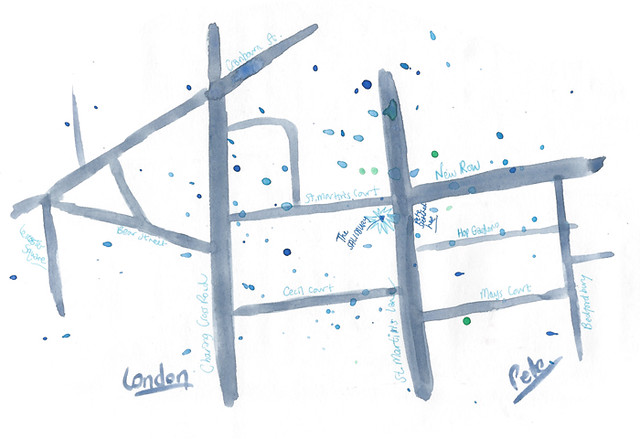
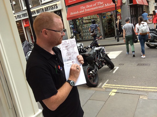
I decided recently that I would do a sketchcrawl in the City charting a course that could let me sketch as many Wren buildings as possible in one day. Not easy, and it would mean not getting super-detailed (I never got my big panorama), but if I invited other London sketchers, perhaps we could do it, perhaps we could cover them all. I created the map above (click on it for more detail) showing which Wren churches are left – there were more originally, but Father Time and the Luftwaffe trimmed down the numbers somewhat. I gave this map to everyone, as we met up at the Monument, and off we went. I love meeting London’s sketchers!

The Monument sm

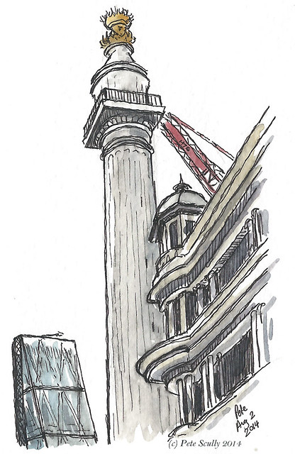
We started out at The Monument to the Great Fire. Built by Wren and topped with a blazing golden ball, if it fell over it would rest exactly where the fire started, which must have made the city planners a little nervous (“Likely to fall over is it then, Chris?”). When it was built it was the tallest column in the world. You can walk up the stairs to the top and look out over the ever-changing skyline. I sketched it quickly, with one of the newer skyscrapers in London behind it, I think it’s called the Cheesegrater, because all of London’s new tower blocks have to have some silly name or other. If the Monument were built now it’d probably be called the Bunsen Burner or something.

St Magnus Martyr sm

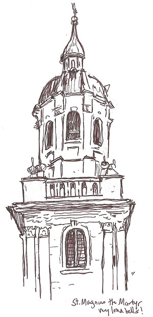
Here is my very quick sketch of the tower of St. Magnus the Martyr, just downhill from the Monument. I recall telling people on my old tours of London that this was London’s most haunted church, but I don’t recall why (probably something to do with ghosts). The bells were very loud and chimed for the longest time, as traffic belted by. St. Magnus used to be right on the River Thames, right by London Bridge itself, its clock being used by ships and bridge traffic for centuries, but as the embankments were built and bridges widened another building has now blocked its riverside view.

St Clement Eastcheap sm

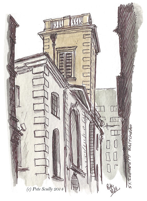
I crossed over the busy traffic junction at King William Street and Cannon Street, and found the rather unassuming St. Clement’s Eastcheap. St. Clement’s…now where do you know that from, ah yes the famous song, “Oranges and Lemons”. This is the St.Clement’s of the song, not St.Clement Dane (the more famous one, located on Strand), and probably so alluded to because of the fruit cargoes offloaded from the riverboats nearby. Or maybe just because it kind of rhymes with lemons. I sketched in an alleyway. It’s not one of the more interesting pieces of Wren architecture. In fact it’s almost as though he couldn’t be bothered at all. “Oranges and lemons, do me a favour, I’ve got fifty-odd churches and a bunsen burner to build,” he was reported to have said, before designing the more handsome and dashing St. Clement Dane. This one is the forgotten little brother.

St Edmunds sm

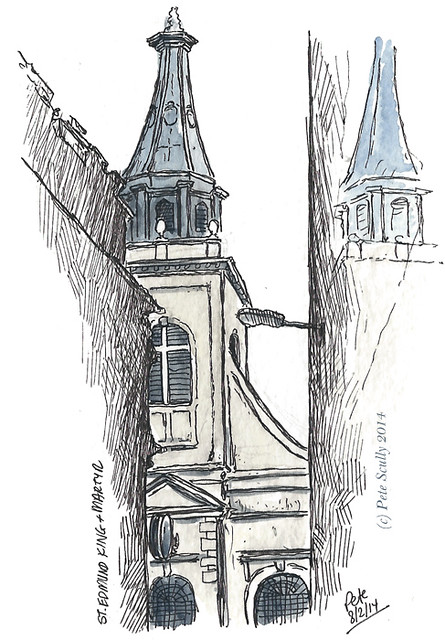
Further down that same alleyway I found the church of St.Edmund, King and Martyr. A lot of Martyrs around here. I have a joke for you, what is King Edmund’s favourite sauce? Martyr Ketchup!     …   Anyway, as you can see I attempted to draw the reflection in one of the shiny buildings, so I hope that’s obvious somehow. Standing on Lombard Street, in the shadow of mightier structures, St. Edmund’s is no longer a practicing parish church but is home to the London Centre for Spirituality.

St Stephen Walbrook sm

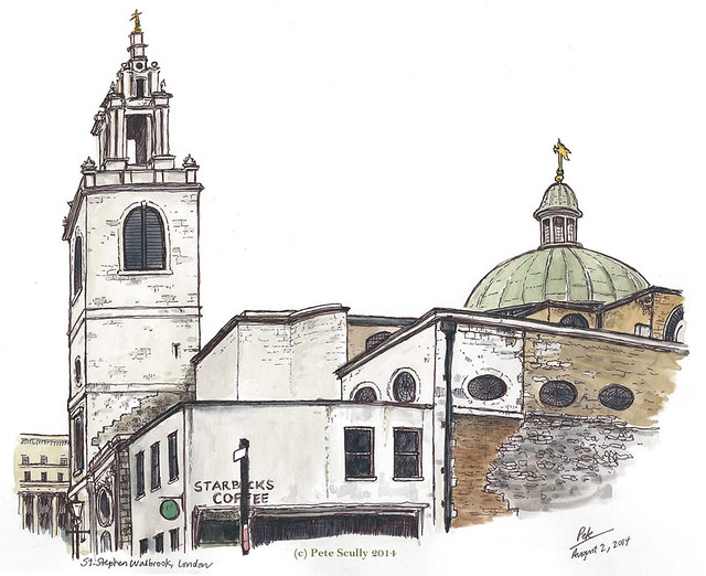
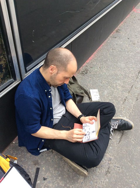
I met my good friend Simon (seen below sketching in messy charcoal), the actor and TV Tsar (no really, watch Houdini on the History Channel this week, he plays the Russian Tsar) and my friend Tamara (herself a stage director and playwright), out sketching with her family, and we sketched the wonderful domed church of St. Stephen Walbrook, one of Wren’s most beautiful churches. Oh, on the inside that is. It was closed this day (doh!) so we made do with sketching its wonderful exterior, Starbucks and all. Still, it was very nice to catch up with old friends and do some sketching. St. Stephen Walbrook by the way was Wren’s dummy-run for St. Paul’s (spoiler alert for part two, St. Paul’s is domed as well) and the inside truly is a delight to behold, ok it’s not the Aya Sophia or anything but it’s still lovely. You’ll have to just imagine it I’m afraid, or maybe I will just sketch it next time.

Sketching Wren's City, Aug 2 2014

Please join me tomorrow for more urban sketches in Part Two: Wren’s Wrevenge…

the mother of all parliaments

parliament square sm

Parliament Square! Click on the image for a closer view. After sketching the Royal Court I went back to Westminster, and stood in Parliament Square to sketch a panorama of the Palace of Westminster, that is, the Houses of Parliament. I know what you’re thinking, I spent a lot of time sketching the tourist attractions this time and not enough time sketching little newsagents or hidden side-streets, but they are all to come, don’t worry. When I passed through the frankly impossible Parliament Square I thought, well why not. There really is a lot of traffic around this square, and not many crossings to get into the middle; it’s never been one of my favourite places. But in the golden sunshine, what a spectacular view! When I was a tour guide I loved the turn into this square, it was almost cinematic with Big Ben (yes I know it’s the bell) and centuries of history unfolding all at once. We’ve had a parliament here since the thirteenth century, though most of the Palace of Westminster – including the Clock Tower (that houses the bell Big Ben), now officially called “Elizabeth Tower”, being renamed in 2012 after the Queen’s Diamond Jubilee –  was built in the 1800s by Sir Charles Barry after the old palace burned to the ground. The oldest part of the building is Westminster Hall, built by King William II (William Rufus) in around 1097. That’s the part with the big sloping roof.

The square is, naturally, a popular place for protest movements. On the left is Parliament Street which leads to Whitehall, many of the British government buildings are located here. Westminster Bridge leads off, over the Thames; in the distance there you can see the Shard, tallest building in Europe. I’ve included the statue of Winston Churchill which, I was told when training as a tour guide, is actually electrified with a low voltage to prevent pigeons from sitting on his head. “We will fight them on the statues.” It’s hidden away a bit but you can just make out the statues of Oliver Cromwell, former Lord Protector, a strange choice for a statue outside Parliament because despite leading Parliamentary forces in defeating the Royalists in the Civil War, he did also shut Parliament down as and when it suited him too. On the right hand side you can just about make out St. Margaret’s Church, the parliamentary church; on my old tour I would joke that it was a place where Tory and Labour MPs would go and pray together but not the Lib-Dems because they haven’t a prayer, tee-hee, well times have changed now haven’t they. This church backs onto Westminster Abbey.

parliament square bigben sm

Here’s a close-up. I worked in Westminster Hall once back in the 90s, serving tea as part of a catering job I was working on (it if I recall rightly a Jewish single’s night organized by the MP Oona King). I remember walking about the amazing building, seeing where William ‘Braveheart’ Wallace was tried before his execution, wandering about the old stone corridors and hearing voices echoing down the stairwells. I went to the toilet, and remember the booming sound of Big Ben making me jump, opening the window and seeing the large clock face right there. I do love this old building.

Here’s a map showing whereabouts I stood. After this, my drawings were done for the day, and I spent the rest of the afternoon mooching around bookstores.

westminster map

oh so soho

Berwick St panorama sm

My first two-page street panorama in London! Click on the image to see it in closer detail. This is the intersection of Berwick Street and Broadwick Street, looking down towards Wardour Street in Soho, the heart of London. I have loved Soho since I was a teenager, all its narrow, slightly grimy streets, alleys and shortcuts. I love sketching down there, in this neighbourhood between the Big Streets. Do you know why it’s called Soho? I used to tell people it’s because it is “South of Hoxford Street”, and some people even believed it, but in fact the name comes from an old hunting cry (“So-ho!”, like “Tally-Ho!”). This area in fact used to be a hunting ground in years gone by (yes, yes in some ways it still is, ha ha, very funny). Now, the hunting ground would be bordered by posts which were painted blue, and that is why there are two pubs in Soho called the Blue Posts, one of which is in the middle of the panorama above. Here’s a close-up, below.

blue posts pub, soho

Ok, there’s some history for you. This is on the edge of the Berwick Street Market, which has its origins in the 18th century. Down the end of Broadwick Street on the corner of Wardour Street used to stand a famous old pub, the Intrepid Fox, which for more than 200 years was one of Soho’s best loved drinkers. I knew it as the rocker’s pub, the best in town (along with the more trad-pub but still rocker-heavy Ship across the road) and used to go there many years ago with friends before heading to the Hellfire Club, but alas it eventually closed down, and is now a gourmet burger restaurant. What a shame. The Ship’s still there, unchanged. I think I’ve only been into the Blue Posts once, but this is the second or third time I have drawn the building. I spent two and a half hours standing there on the corner opposite, sketchbook in hand (Stillman and Birn Alpha landscape). Occasionally tourists and passers-by would stop and look, or ask me for directions (“Excuse me,” one Italian guy asked, “where is Soho?” Right here, my friend, right here.)

Pete sketching SohoPete sketching Soho

Here I am sketching, in a photo taken by Random Passing Chinese Tourist. And below, the sketchbook-selfie (really? That’s what it’s called?) showing what I was able to do on site. Two and a half hours of penwork. I added all the watercolour when I got home.

Sketching Berwick St

Around the corner, the Soho staple art store Cowling and Wilcox now stands empty, closed after fifty years, though they are still open in other locations. A representative from Cass Arts around the corner was stood outside handing leaflets to people directing them there instead, but I told him I didn’t need one (I had just been to Cass). He didn’t take that for an answer and told me to take the leaflet. No thanks mate, I don’t need one. “Take it anyway,” he insisted. No, I don’t need one. “Take it and throw it away then,” he kept on. I don’t want a leaflet, mate, will you leave me alone. He wouldn’t. “You’d be doing me a favour by taking the leaflet.” He was quite pushy. No mate, please leave me alone. He glared for a while incredulous at the idea that I wouldn’t take a leaflet telling me where a store is that I have just been to but then left it and started bothering other people. That’s Soho for you, but there are sometimes pushier sales-folk on these streets, if you know what I mean. By the way, there is another sketch I did in Soho that afternoon, around the corner on Brewer Street. It’s a cool looking shop called Lina Stores Ltd on the corner of Green’s Court, and I just had to sketch it.

Brewer St, Soho

And that was the end of my first day back in London! Here’s a map of Soho showing where these two were sketched. IT doesn’t show the previous two from earlier in the day but well, you can figure them out.

soho map

i’m really up the junction

A & 3rd Davis
Here is one from a month ago…getting there slowly… This is the junction of 3rd and A streets in Davis, at the entrance to the UC Davis campus. Imagine all the cyclists that come through here every day! Running through that Stop sign, barely dodging pedestrians, this is what Davis is all about. There’s a big second-hand textbook store across the street. My oldest friend sells academic textbooks, funnily enough, but he lives in Korea now. Here is the map, in case you are just not sure where this could be.
A & 3rd map